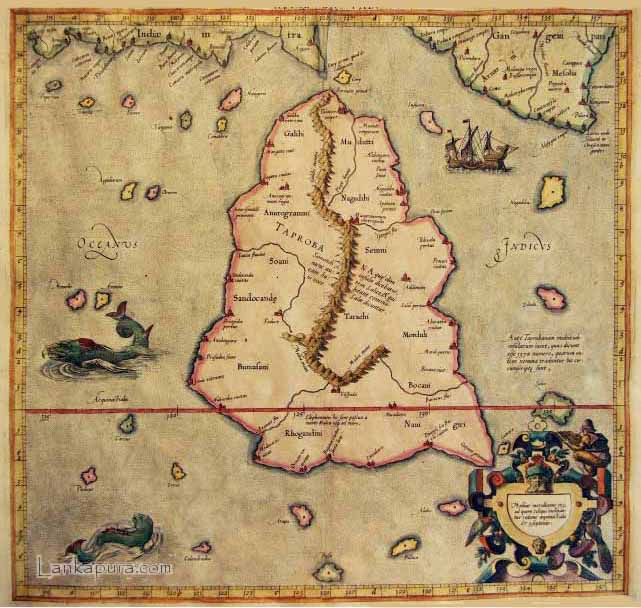
Taprobana is actually Ceylon, although it was sometimes confused with Sumatra on some maps. Taprobana, as it was called on most early maps, was an important post for trade between the east and the west, and was drawn too large on many maps because of its importance.
The Exotic Island of ‘Taprobana’: Sumatra or Sri Lanka?
The Debate Continues
By Bandu de Silva
source: Island.lk
The old question if the isle of Taprobana shown in the map of the world drawn by the Greco-Egyptian cartographer and mathematician, Claudius Ptolemy was Sri Lanka or Sumatra has resurfaced recently with the display at the Australian National Library (ANL) Map Gallery during the months of January to March (2008), of Sebastian Munster’s map of Taprobana drawn in 1580 carrying the German title, ‘Sumatra Ein Grosser Insel’, (Sumatra, a large island). The old debate was settled earlier in favour of Sri Lanka, but the more recent display of Munster’s map with its title has reignited the debate.
The ANL Map exhibition came to my attention as I was planning during my recent visit to Australia in January/ February, to visit the ANL which was one of my favourite haunts during my days in Canberra four decades back. That was a time one spent spare time either playing golf, tennis or bridge and partying with week-end barbeques besides, warding off bush flies when outdoors. Canberra has transformed from that dull city it was in 1970, with 30,000 people around when I left the place. Today, it has become a Capital where many events take place at a given time that it is difficult to choose from and prior bookings are necessary.
I was first taken to the new ANL site over 40 years ago by the former Parliamentary Librarian who was referred to as one of the “Three Imps” who ran the affairs of the country along with Sir Aurthur Menezies, then Prime Minister. The ANL building under construction, which was one of the first new landmarks to change the skyline of the Australian Capital Territory (ACT) was then coming up floor by floor with its construction and opening date schedule displayed at the site. Very soon it grew up to be one of the most modern and fully equipped libraries in the world. At the time I left Canberra 37 years ago, the library which had been functioning for about two years, had just acquired a complete old Portuguese Library with its curator, one Dr. Braganza. I was rather sad that I could not delve into that section of the library at the time as it was not ready for use.
During the revisit to Australia as a guest of my old friends, I was privileged again to visit the ANL and skim over its vast array of daily activity which at that time included the Exhibition of Maps and Japanese Film Nights among other programmes.
On Munster’s map of Taprobana, which was on loan to the Gallery, Damian Col, the assistant curator of the ANL was quoted in Canberra Times saying that Munster’s map was “a fine example of the difficulties Renaissance map makers had in placing the continents of the world. It showed “the cartographic confusion that Europeans had trying to understand the geography of Asia.”
By the time Munster’s map was produced based on Ptolemy’s map, which had been lost since its production around the 2nd century A.D., and some copies were rediscovered in the Middle East around 1400 A.D., the Portuguese had had made their way into Asia. They had knowledge of both Sri Lanka (then Ceylan) and Sumatra, a knowledge which was at least 80 years old. So one may ask if Munster based his identification of Taprobane with Sumatra on 16th century knowledge.
What still baffles everyone is the exaggerated size of Taprobane if Ptolemy really meant the isle to represent present day Sri Lanka. In contrast, the sub-continent of India which is shown in the map is far smaller in dimensions. It was true that Sri Lanka by Ptolemy’s time was a well known island as it was centrally situated in the Indian Ocean (see JRAS (CB)- Nicholas: ‘Historical Topography of Ancient and Medieval Ceylon’) but India and her products were equally known from the pre-Christian era, starting with the Persian occupation of territory up to the river Sind and Alexander’s conquests following that as well as through sea-borne trade (see Mcrindle & others).
On the contrary, Taprobane, despite tits sheer size, was assigned by Ptolemy with trade in elephants and golden spices. Both Sri Lanka and Sumatra were known for these two commodities, and the latter more so for spices but it is Sri Lanka which had better historical record for elephants. The intelligence displayed by Sri Lankan elephants and easier transport across the Indian continent perhaps, accounted for preference for them. Sri Lankan elephants began to be exploited in a big way only after the East African resources dwindled. (UNESCO History of Africa).
There are no records of Sumatran elephants being sought after in Europe or India but an Australian biologist told me this time that elephants were known in Sumatra though the records may not be forthcoming. This aspect, however, needs further investigation. John Still in his book, Jungle Tide, writing on the road making ability of Sri Lankan elephants suggested that they be introduced into the [dense] tropical forests of Papua New Guinea which seems to be an assertion that elephants were not known there. One aspect to be examined is if dense tropical jungles of Sumatra would have provided an ideal habitat for elephants.
Identification with Sri Lanka
Fergusson, in his two paged note written in the Royal Asiatic Society (CB) Journal quoted Major Forbes (of elephant hunting fame), as his authority in identifying Taprobane with Ceylon. Forbes wrote: “I am inclined to suggest that the name Tambapani, Tambapanni, Tambraparni, of the Pali historians, which has been corrupted into Taprobane by those of the western world. It was in the district of Tamena, or Tambana, or Tambapanni that Vijaya [first conqueror] landed…” However, he was inclined to place Tammmenna on the Eastern sea board going by the mistaken similarity with the name Tamankaduwa.
Emmerson Tennent, the other authority who identified Taprobane with Sri Lanka (then Ceylon), wrote: “From his position in Alexandria and his opportunities of intercourse with mariners returning from their distant voyages, he enjoyed unusual facilities for ascertaining facts and distances, and in proof of his singular diligence he was enabled to lay down in his map of Ceylon the position of eight promontories upon its coast, the mouths of five principal rivers, four bays, and harbors; and in the interior he had ascertained that there were thirteen provincial divisions, and nineteen towns, besides two emporiums on the coast; five great estuaries which he terms lakes, two bays, and two chains of mountains, one of them surrounding Adam’s Peak, which he designates Maloea –the name by which the hills that environ it are known in the Mahawanso. He notices,in passing, the fact that the natives wore their hair then as they do today, in such length and profusion as to give them the appearance of effeminacy …..”
Tennent, thus identifies Ptolemy’s Taprobane with the island of Ceylon, ignoring the exaggeration of the size of the island. The question of doubt arising from the size arose subsequently with the discovery and publication of Munro’s map referred to.
Since Cooley and Tennent, several cartographers have tried a different approach by trying to identify the places mentioned by Ptolemy with modern-day places. In this process, it has been revealed that a few place bear Persian names (See Denis Fernando) like Phasis fluvius (for Mahaweli where the Persians lived) and “Cindo Canda Civitas (township of Sinds and Sandocanda with the area North of Kelani to Deduru Oya where the Sindh tribes lived. (‘Sandokan’ is a name I found used in modern Iran after the story of Sandokan). Denis Fernando has identified Phasis Fluvius with River Mahaweli and Cando Canda Civitas with Chilaw.
A few of other geographical and tribal names which fit into Sri Lanka are: Anurogammi,(Anuradhapura} Rhoghandini,(Rohana), Tarachi, Nagadibi,(Nagadipa), Moduttu (Nicholas:Mahatittha; Denis Fernando: Seruvila/Lanka Patuna) and Maargammum (near Badulla) and Tarachi (Tarachhcha) and Salai (Sihala). Tennent observes that the extent of Ptolemy’s information is so surprising that it has given rise to the surmise as to the sources whence it could possibly have been derived.
This confirms the idea of Cooley and Tennent that Ptolemy based his knowledge on what Greek [and Persian] mariners had accumulated. Sri Lanka by that time (early Christian centuries), had a developed civilization with a continued dynastic rule and her reputation itself may have led the Egyptian cartographer to give exaggerated dimensions of the island, besides problems of calculating longitudes and latitudes. In contrast, the high civilization of Sumatra seems to be a latter day development though Acheh might have developed its sea borne contacts with Africa and the Gulf earlier. When Munster produced his map in 1580, Sumatra including Acheh were, perhaps, better known in the West.
Explaining the confusion in application of the name Taprobane to two places, Damian Cole explained that Ptolemy’s atlas was lost, and Europeans looked inward for many years without really expanding beyond their borders, from about 400-500 A.D. up until about the early 1400s, when some copies of Ptolemy’s atlas that had survived in the Middle East were found again. He continued: “As the Europeans started to explore again they came across Sri Lanka, and thought well this must be Taprobane. But at the same time another route to the Indies was further south across the Indian Ocean and explorers came across Sumatra in Indonesia. … So a debate began whether Tabrobane was Sri Lanka or Sumatra, as both fitted the description of an exotic island with golden spices and elephants. ….Because of the difficulties of calculating the longitude and distance they underestimated the size of the Indian Ocean. They initially thought it was the same place, so Taprobane started to be applied to two different places. …When it became clear they were two different islands, the name was applied to both. In this case, to make things more muddled, a map of the island [of] Sri Lanka is called Sumatra [and named Taprobane]…..Most scholars today agree that Taprobane was Sri Lanka, but at the time, the identity of the ancient island was the subject of some debate.”
I am reopening this subject on the basis of what I saw at The Map gallery of the ANL in Canberra and the views expressed by the assistant curator as I thought it my interest our cartographers and scholars who may wish to express their views on the confusion caused by Munro’s map which is on loan to the ANL.
I Love Sri Lanka
May be Ptolemy is right if the sunken landmass found below SL is the part of Taprobana.
http://www.lankanewspapers.com/news/2009/4/41736_space.html