Ancient map of Anuradhapura - Sri Lanka 1938 #IMG109
Anuradhapura map
Publisher: ‘A handbook for travellers in India, Burma and Ceylon’ edited by Sir G. Hearn, 15th edition, (London: J. Murray; Calcutta: Thacker, Spink and Co., 1938).
Date(s): 1938.
2 thoughts on “Ancient map of Anuradhapura – Sri Lanka 1938”
Anuradhapura is the oldest city in acient in Sri Lanka and most recent city to have been designed as a 20th century city. The government decided to remove all residences from the old city (sacred city) developed the new city as you see it today under the Anuradhapura Presevation Board project starting from 1940s. That is why you will see the well demarkated roads with strategically placed roud-abouts (traffic circles) and schools.
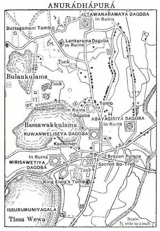
Anuradhapura is the oldest city in acient in Sri Lanka and most recent city to have been designed as a 20th century city. The government decided to remove all residences from the old city (sacred city) developed the new city as you see it today under the Anuradhapura Presevation Board project starting from 1940s. That is why you will see the well demarkated roads with strategically placed roud-abouts (traffic circles) and schools.
I AM PROUD ANURADHAPURA